This site is currently under construction. Please check back from time to time to see what
new information has been added.
new information has been added.
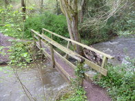 Habberley Brook
© Jeremy Bolwell
Habberley Brook
© Jeremy Bolwell
THE parish of Church Pulverbatch lies on rising ground in the northern foothills of the Long Mynd. It contains 4,283 acres and comprises the townships of Church Pulverbatch (known locally, since at least the 13th century, as Churton), Castle Pulverbatch, Cothercott, Wilderley and Wrentnall. The parish boundary in part follows streams; Habberlev Brook on the west, Ipkins (or Walleybourne) Brook on the north, and Wilderley Brook on the south-east. On the east, however, and over Wilderley and Cothercott Hills to the south, it passes through former woodland and does not make use of natural features. The eastern boundary with Stapleton, although determined in 1385, was in dispute in the later 16th century. It was not settled until 1610, when an area known as ‘the Challenge Land’, between Castle Place and Churton Brook, was transferred to Pulverbatch. To the south of Churton Brook the parish boundary follows the bounds of Wilderley and Stapleton manors, laid out in 1227. The southern boundary was not determined until the enclosure of the Long Mynd, c.1790. An anomalous projection of the boundary in the south-west corner of the parish, taking in Bank Farm and part of Paulith Bank, was still accounted part of the township of Stitt and Gatten, in Ratlinghope parish, in 1839. This presumably represents the portion of Stiperstones Forest granted to the lord of Pulverbatch.
Besides Ipkins and Wilderley Brooks two other tributaries of the River Cound flow from west to east across the lower northern, half of the parish. Along them ran most of the internal boundaries between the townships. Wildbach Brook, flowing from Broom Hill towards Moat Farm, Stapleton, was the boundary between Wrentnall and Church Pulverbatch, while Churton Brook divided Church and Castle Pulverbatch on the north from Cothercott and Wilderley on the south.
Besides Ipkins and Wilderley Brooks two other tributaries of the River Cound flow from west to east across the lower northern, half of the parish. Along them ran most of the internal boundaries between the townships. Wildbach Brook, flowing from Broom Hill towards Moat Farm, Stapleton, was the boundary between Wrentnall and Church Pulverbatch, while Churton Brook divided Church and Castle Pulverbatch on the north from Cothercott and Wilderley on the south.
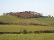 Broom Hill
© Andrew Wood
Broom Hill
© Andrew Wood
The boundary between Cothercott and Wilderley ran along the road to Sheppen Fields, and that between Church and Castle Pulverbatch was the valley to the east of the road from Shrewsbury to Bishops Castle.
Over the east and north of the parish the land rises gently from 400 feet in the north-east to some 650 feet near the villages of Church Pulverbatch and Wrentnall and the sites of the former hamlets of Wilderley and Walleybourne. Castle Pulverbatch stands at 700 feet, the only hill village being Cothercott (800 feet) on the north-eastern slopes of Cothercott Hill. The landscape in the west of the parish is dominated by a northward projection of the Long Mynd, comprising Broom Hill (950 feet), Lawn and Huglith Hills (1,050 feet), and Paulith Bank (1,263 feet), and forming the watershed between Habberley Brook to the west and the Cound tributaries to the east. South of Wilderley and Cothercott rise the steep slopes of Wilderley and Cothercott Hills, the latter reaching 1,450 feet at its summit near the Thresholds.
Although the parish contained six ancient townships, the greater part of its area was covered by forest until the later 16th century. Steplewood, on the eastern clays, extended into Stapleton and Pontesbury parishes and Wilderley Wood, its southern continuation, ran southwards from Wilderley Brook into the foothills of the Long Mynd. Woods known as Walleybourne Wood, Broom Hill, and Over and Nether Huglith lay on the clay flanking the range of hills in the west of the parish. Extensive commons on Wilderley and Cothercott Hills were not enclosed until the Second World War.
Extract from Victoria County History, Shropshire Vol VIII 1968